Bitter Cold Snap Brings Record Breaking Wind Chills and... Frostquakes?
An arctic air mass brought record breaking wind chills, stratospheric winds, and frostquakes to parts of the northeast this past weekend.
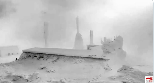
One life-threatening cold snap moved into the northeastern part of the United States this past weekend, setting a new national wind chill record. On Friday evening, a new record was set at Mount Washington in New Hampshire with a wind chill of -108°F. Actual temperatures at Mount Washington were -46 ° with a wind speed of 100-110 mph and gusts up to 127 mph.
❄️💨❄️This is EXTREME WEATHER! Right now Mount Washington is living up to the reputation of having the worse weather in the world.
— NWS Cleveland (@NWSCLE) February 3, 2023
INSANE conditions Temp -42° F, Wind Chill -101° F, Wind Gusts 127 mph! https://t.co/vr4pGu9p7G
From the summit cam 230-240pm. #OHwx #PAwx pic.twitter.com/6N30euV9oL
What is a wind chill?
Wind chill can be commonly confused with temperature. Temperature is the measure of hotness or coldness exerted from a body. Wind chill is the intersection of your actual temperature and the wind speed. An easier way to remember this- temperature is what the thermometer reading and wind chill is what it feels like.
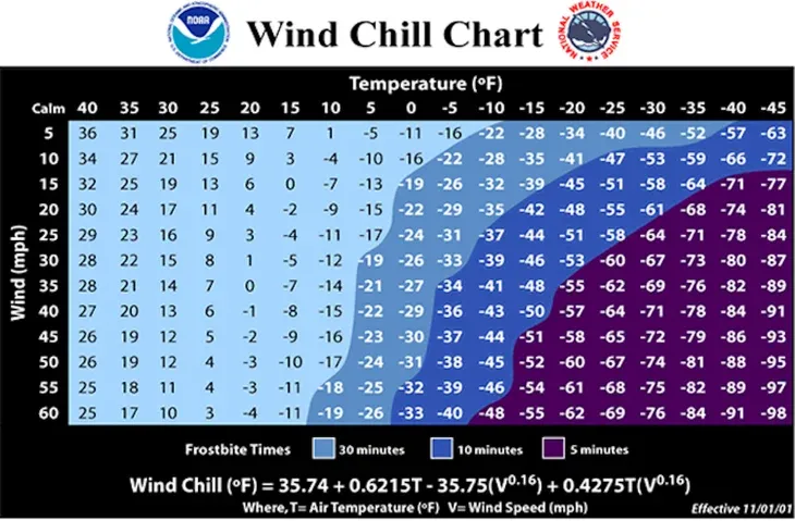
Wind chill is always cooler than the temperature but how do scientists figure this out? Simply by using the wind chill calculation, where T = temperature in Fahrenheit and V= wind speed:
35.74 + 0.6215T – 35.75(V0.16) + 0.4275T(V0.16)
Or, you can use this chart to look at a wind chill, but notice it doesn't go below -98°F. It's very rare for any wind chill to drop below that number.
Out of the Troposphere
What makes this situation even more fascinating is the fact that the summit of Mount Washington was actually in the stratosphere, one atmospheric layer above the troposphere. But, how is this possible?
We currently live in the troposphere - that's where almost all of the weather takes place. On a regular day, the bottom of the stratosphere lies somewhere between 30,000 and 40,000 feet. However, when an arctic air mass, similar to this one, moves in, the cold, dense air sinks. This forces the troposphere levels much lower than usual. Early Saturday morning, the border between the troposphere and the stratosphere was located at 5,000 feet.
Mount Washington is the highest peak in the northeastern United states, at 6,288.2 ft or 1,916.2 m. This would make Mount Washington surpassing the border of the troposphere and moving into the Stratosphere. This phenomenon is called a tropopause fold and is fairly uncommon to see.
But along with record wind chills and bitter cold temperatures, there were also frost quakes in the area of Maine.
And frostquakes?
Frost quakes are not real earthquakes, but they may feel like it. The phenomenon occurs when temperatures drop rapidly, causes underground water to freeze. When this happens, the ice expands due to its nature, putting extra pressure on the bedrock and soil surrounding the area. This pressure continues to build until the soil and the rocks begin to crack, which can result in a loud 'boom' or shaking. A few of these quakes were reported in Maine as temperatures started to suddenly drop on Friday.
We are getting Reports of hearing/feeling "Quakes" across the area. These are Frostquakes also called Cryoseisms. Just like Earthquakes, generate tremors, thundering sensations. These are caused by sudden cracks in frozen soil or underground water when its very cold. #MEwx #Maine
— NWS Caribou (@NWSCaribou) February 3, 2023
Temperatures began to rebound on Sunday morning, as a warm front surpassed the area. This will leave many to see above average temperatures compared to the bitter, well below average temperatures this weekend.